
How can geospatial technologies lend a helping hand in providing a better virtual experience and shaping a more productive future?
When you are lost on the street, you probably will use your phone and check your favourite navigation app to find the correct route. The whole process is so effortless that you may not realize how sophisticated it is to capture the entire street view in 3D and display it on the 2D screen of your mobile phone.
Such technologies and experiences are made possible using geospatial technology.
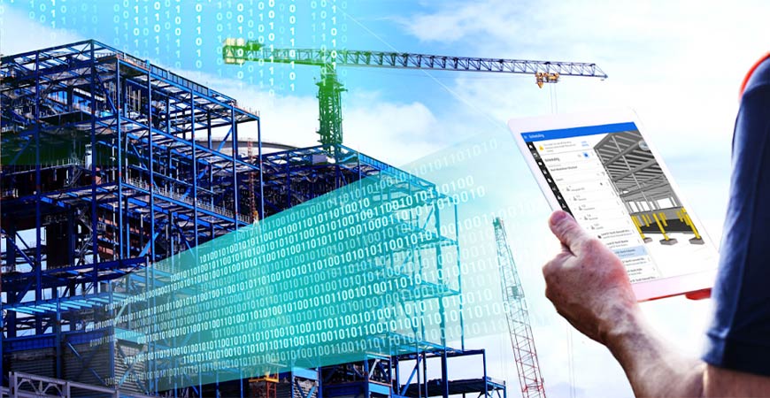
Geospatial technology refers to a collection of technology and processes to capture and understand data associated with location. This can range from satellite-based technologies mapping and monitoring the Earth to precise positioning technology in the hands of professionals designing and building the world’s infrastructure.
Besides the real world, this technology can also be applied in the virtual world to increase its fidelity at an increasingly lower cost than the creation of a modelled replica. Hence, to make sense of how this technology can be used to create a more immersive metaverse, we spoke to President Asia of Leica Geosystems (Part of Hexagon AB), Mr Faheem Khan. Revolutionising the world of measurement and survey for 200 years, Leica Geosystems creates complete solutions for professionals across the planet. Known for trusted products and innovative solution development, professionals in a diverse mix of industries, such as aerospace and defence, safety and security, construction, and manufacturing, trust Leica Geosystems for all their geospatial needs.
Creating the metaverse using geospatial technology
Up until very recently, geospatial technology was largely used in the “professional space”, mapping and locating elements in the world, either for the most complex engineering and construction projects or for land management purposes. Khan explained this in very simple terms discussing how tools like autonomous drones would be flown over cities to get an aerial view and vehicles would be driven around the cities for a surface-level view. This data would then be combined and layered on top of each other to create a digital twin of cities, at a scale and cost not possible before. This advancement in technology and the growing appetite for accurate, reliable, cost-effective data has created new use cases and industries profiting from geospatial technology today.
He then posits that if we consider the metaverse an extension of the real world, the same techniques used to document objects in the real world would be required to create a replica of them in the metaverse. “And geospatial technology is perfectly suited to build not just a one-to-one replica of small objects or projects, but to create and maintain a digital twin of the dynamic planet we live in” he added.
And this technology is not just being used in creating the metaverse but also in producing more life-like environments in the gaming industry. Khan says that over time as technological development progresses, the difference between the real world and the virtual world is narrowing. “I think, youth, the future generation, is already in that melted dimension. Turn on your gaming console and you’re already very much in that blended space,” he explained.
Intersections between geospatial technology and the metaverse
Using geospatial technology in the metaverse is not only beneficial in improving the gaming experience. Khan details that the true benefit of a realistic metaverse is to accurately simulate outcomes, like fire drills, construction sequences and autonomous navigation in a real-world setting. “If we can immerse users into a metaverse and serve them a user experience that supports things like simulation in a digital but natural space, this new way of doing will solve some very fundamental needs,” he said. He added that companies are using the metaverse to run such simulations to avoid putting their employees at risk while still training them for worst-case scenarios, for instance.
Besides simulating such possible scenarios, he said that another benefit of creating immersive experiences is to improve workplace efficiency. He asked us to imagine a site worker who has noticed a deviation in the building he is working on using the geospatial data that had previously been collected. Traditionally, to see how the deviation is affecting things on the ground, the worker would take a printout and go to the field. “Wouldn’t it be better if I can just go to the job site, put on a device, maybe HoloLens (mixed reality smart glasses created by Microsoft), and immerse myself in that 3D space against the real world?” he questioned.
While we have focused on how the metaverse created using geospatial technology can help us do things in the real world, this technology can also be used in making decisions within the metaverse. Companies can use geospatial data to select viable pieces of virtual land for development in the metaverse. Yes, much like in the real world, property sales in the virtual world would also be about finding the best location and that can be achieved using geospatial technology. Corporations can rely on the geospatial data of a metaverse to find out whether the plot they want to buy and develop into their storefront would be likely to get footfall.
How the metaverse will grow over time
Khan is extremely hopeful about the future of the metaverse. “I think we are at an intersection of technology and user maturity, which will drive adoption [of the metaverse].” He added that “the trends point to the increased interconnection of the real and virtual worlds”.
He explained that end users have an increasing appetite for high-resolution visuals. “When it comes to geospatial technology, we want infinite fidelity, we want high resolution, and we want to capture space at low cost and higher fidelity.” He further added that there are still ways to go till the right balance between low-cost data collection and high accuracy can be achieved, though the BLK series of products (Leica Geosystems 3D reality capture portfolio) has disrupted this space and shaped the future. Khan also shared that Hexagon AB acquired the augmented reality (AR) tech developer Immersal last year and that this acquisition will help the company refine its capabilities in creating immersive virtual environments.
Khan spoke about the geospatial industry’s foray into the metaverse in a panel discussion at Geo Connect Asia 2022. To get an opportunity to hear from experts in the geospatial community, make sure to check Geo Connect Asia’s website.
Also read:
- How the Metaverse Will Change the Future of Workspace
- Virtual Office in the Metaverse – the Accenture Nth Floor
- What Are the Different Emerging “Metaverses”?
- What is Virtual Real Estate?
Header image courtesy of Leica Geosystems’ website